Why a River Bend Can Give a Walk Its Shape
A river bend can help you orient a countryside walk by linking banks, paths and crossings, so the route follows the landscape rather than a mileage target.
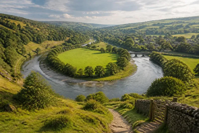
A river bend can give a countryside walk a clear shape before you set out: follow one bank, notice where the water turns, and decide whether a crossing belongs in the day. That simple way of reading a river bend helps you orient the route without treating distance as the main measure of a satisfying walk.
What does the river tell you before you choose a path?
Begin with the river’s broad course, not with a line on a map. A bend changes what you can see and how the banks relate. On the outside of a curve, water often meets a steeper, more exposed bank; on the inside, the ground may be flatter and the current slower. These are useful clues, not promises: local geology, flood works and vegetation can alter the pattern.
Look for features that remain easy to recognise as you walk: a bridge, a confluence where a smaller stream joins, a mill leat, a church tower above the valley, or a distinct wooded point. Together, they make a sequence. The river becomes less like a line to follow and more like a page with landmarks placed along its edge.
Before leaving, check a current map for public rights of way, bridges and access points. A river may look close enough to follow, yet the bank could be private, fenced, marshy or cut off by a steep slope. The best route is the one that uses the river’s shape while staying on paths you are entitled and able to walk.
Which kind of river bend suits your walk?
If you want an easy sense of direction, what fits?
Choose a route that follows one bank for a while, with a bridge or recognisable feature as a turning point. Keeping the river on the same side makes orientation straightforward, and the bend offers a natural cue to pause and check where you are. This suits a relaxed walk when you would rather pay attention to the valley than consult a map at every junction.
If you want changing views, what should you choose?
Look for a path that crosses the river or climbs above a curve, so you can see the same bend from more than one angle. From the bank, a bend may conceal what lies ahead; from a higher path, it can reveal the river’s wider course. This option suits walkers who enjoy comparing close details with a broader landscape, provided the ascent and descent fit their ability.
If the banks are uneven or access is limited, what fits?
Use the river as a reference rather than insisting on walking beside it. A lane, field-edge path or ridge track may run parallel to the water while avoiding a wet or obstructed bank. This is often the better choice when one side has no public path, or when a narrow valley makes the riverside ground difficult to pass.
If you have a short window, where should you turn?
Pick one bend and a clear return point, such as a bridge or village path junction. Let the visible curve be the purpose of the outing rather than trying to reach the river’s next distant landmark. This fits a short walk because it gives you a natural point at which to turn back, without making a particular distance the measure of success.
How do you read the two banks?
The banks can offer different experiences even where they appear close together. A path on the inner side of a bend may pass damp meadow, reeds or silted margins; the outer side may rise beneath trees or expose a cut in the earth. Notice which features are present rather than assuming that either bank is always easier or more scenic.
Bridges matter because they connect those different edges. A bridge can turn a one-bank walk into a route with changing perspectives, but it can also be the only legal crossing for a long stretch. Check its location and the paths leading to it before setting out. A crossing shown on a map may be a road bridge with fast traffic, while a footbridge may be seasonal, closed or absent from an older map.
At a confluence, the river’s identity can become less obvious. Follow the main channel shown on your map, then use a bridge, stream mouth or village name to confirm your position. This is especially helpful in low, wooded ground where the water itself may disappear from view for a time.
What if you cannot stay beside the water?
A river route need not cling to the bank. In many valleys, the best way to understand a bend is to leave the water briefly and return at a point where the view opens. A footpath across a field may lead to a lane above the floodplain; a wooded track may skirt a wet patch before rejoining the river. These detours are not failures of the route. They show how the terrain and access shape the journey.
Use the bend as a compass-like reference, not a demand that every step follow its edge. If the river turns out of sight, note whether your path is moving towards or away from its curve. A map’s contour lines can clarify whether you are staying on the valley floor or climbing a slope. The river may also change direction more sharply than the path, so compare landmarks rather than expecting a perfect parallel line.
Say you begin at a village bridge and want a gentle afternoon walk. You follow the public path along the near bank until the river swings behind a wooded spur, then take a signed field path towards a lane and return by a second bridge. The expected result is a route with a clear outward reference and a different view on the way back, even if the riverside path itself is not continuous.
How can you keep the walk from becoming a mileage target?
Choose a feature that gives the walk a reason to unfold: the point where the river bends out of sight, a bridge framed by trees, or the place where a tributary enters the main channel. Decide what you want to notice there. You might compare the sound of water at a narrow reach with its quieter flow in a wider curve, or watch how a path rises above the floodplain.
This is a little like following the rim of a bowl: the shape guides your movement, but you do not need to trace every inch of it. If a path becomes muddy, crowded or unclear, the landscape still gives you options. Turn at a suitable point, take a marked route inland, or use a known crossing to return on the other bank.
For a more thoughtful pace, pause where the river’s direction changes and look back along the route. The bend may make a familiar stretch appear unfamiliar from the reverse angle. That moment can help you register how the valley is arranged: where the ground rises, which way a lane runs, and how the settlement sits in relation to the water.
What should you check before choosing a riverside route?
- Public access: Confirm that the path is a right of way or otherwise open to walkers; choose a nearby lane or signed path if the bank is private.
- Crossings: Locate usable bridges and the paths on both sides, so the route does not depend on an uncertain crossing.
- Ground conditions: Look for low-lying, muddy or steep sections and choose footwear and an alternative path to suit the conditions.
- Map age: Check that the map is current enough to reflect closures, diversions and changed access, and follow signs on the ground.
- Return options: Identify a village, lane or bridge that gives you a sensible way back if the riverside path becomes hard to follow.
- Visibility: Notice whether trees, high banks or bends are likely to hide the water, and choose a landmark you can still recognise.
Where access rules, closures or local conditions are unclear, follow the land manager’s signs and current local guidance rather than treating the map as permission.
How does a river bend help you find your way?
A bend is most useful when you pair it with another feature. Water direction alone can be confusing, especially where channels split or paths cross the valley. Relate the curve to a named bridge, a road junction, a hill or the edge of a settlement. That combination gives you a more dependable mental picture than trying to remember each turn in sequence.
When you reach a junction, ask whether the path is taking you towards the next landmark or away from the river’s curve. If you cannot tell, stop somewhere safe and compare the map with the features around you. A map is a working aid, not a substitute for observing the ground; equally, a recognisable bend cannot reveal every path or access boundary.
For a walk shaped by a river bend, choose the bank and crossing that suit your ground, time and appetite for changing views. Then let the curve organise your attention: where the water disappears, what lies on each side, and which landmark brings you back to your route. The river gives the walk a sense of direction, while the paths and places along it decide how that direction becomes a journey.